Showing posts with label excursions. Show all posts

Thursday, June 10, 2010

Rheims

Susie and I spent two days in Rheims, which wasn't at all like I had expected. Rheims is famous above all for its cathedral, which was where the kings of France were crowned over a span of a thousand years. But the city is not another quaint assemblage of narrow medieval streets with half-timbered buildings. On the contrary, Rheims is a gracious city of broad esplanades lined with buildings from the 1920s and 30s.

This turns out to be for terrible reasons, but the result is a city that feels like a smaller, lower, and calmer version of Paris. Almost all of central Rheims was destroyed by German shelling in the First World War. The city had been evacuated, so few civilians lost their lives. But the destruction of Rheims's buildings was so complete that the city had to re-envision itself, replan itself, and rebuild itself. Over the course of the 1920s and early 1930s, often with reparation funds, the inhabitants rebuilt their city in a modern idiom, and primarily in the Art Deco style. Here's an example. I'll write blog post that takes readers on an abbreviated tour of some of Rheims's Art Deco buildings.

The cathedral was badly damaged in World War I, as well. It's been rebuilt and restored--indeed, restoration work continues to this day. I'll write another blog post with details on the cathedral and its history.

One of the few buildings to survive World War I largely unscathed (its facade, anyway) was the Grand Theatre, a neo-Classical structure from the Belle Epoque. The auditorium and stage had to be rebuilt after the war. The auditorium is rather intimate compared to some opera houses. It has a glass ceiling surrounded by elegant paintings that must be from the 1920s. Susie and I were able to attend a terrific performance of Rossini's "La Cenerentola." Rossini based his opera on the story of Cinderella, and this staging--a co-production with Spoleto USA and Avignon--certainly lived up to the promise of the magic in Cinderella's tale. The singing was superb, the sets (including computer effects!) excellent, the staging imaginative and funny, and the orchestra sparkling.

One of the best buildings in Rheims is a Carnegie Library, an Art Deco masterpiece from the 1920s. I hope to be able to blog about this building in detail.

Many of the streets in central Rheims are reserved for pedestrians. With a carousel, fountains, monuments, and those Art Deco buildings, these streets bring a charm and liveliness to the city.

And if your feet get tired from walking to see all those buildings, or if you're meeting friends for drinks or dinner, the broad pedestrian avenues of Rheims offer many restaurants, cafes, and bars from which you can choose.

Thursday, June 3, 2010

Dol and Mont Dol

From the flat Breton countryside southwest of the Mont Saint Michel rises le Mont Dol, a rocky outrcropping that, in its form, is a small mountain. Mont Dol's summit provides outstanding views and supports a number of interesting structures, including a windmill. Also on the summit, with the Baie Saint-Michel as its distant backdrop, stands a small chapel, Notre-Dame-de-l'Espérance.

This rustic chapel dates from the first half of the 19th Century. It's the remaining part of an older, larger chapel, dedicated to Saint Michael, that itself had been erected on the site of a pagan temple. The views beyond the chapel toward the bay are beautiful, although on the day we visited Mont Dol there was haze that left the Mont Saint-Michel barely visible on the horizon (and visible in this picture only as a slight smudge at the left edge).

The summit of Mont Dol afforded a much clearer view of the cathedral of the nearby village of Dol-de-Bretagne. The cathedral is a surprisingly large church for a town of this size, reflecting its medieval status as the seat of a bishop.

The village of Dol has a charming old center that provides an enjoyable stroll.

The stroll brings you to Dol's cathedral, named for Saint Samson, a monk from Cardiff who, in 548, founded a monastery in Dol. The present Gothic cathedral dates from the mid-13th Century, mostly. Lack of funds left the Gothic towers of the fairly simple facade unfinished.


The cathedral's interior is more elaborate. Even though it's a large building, it has a sense of lightness. The tracery in front of the upper-floor galleries helps to break up the massiveness, and the slender arches draw your eyes upward. If the exterior is sober, the interior can be rightfully termed flamboyant.

Friday, May 28, 2010

Annecy

On our way to Geneva on Thursday to visit relatives, Susie and I took a little time to stroll through the old section of Annecy, capital of the Haute-Savoie department. Annecy is a gracious resort city and France's proposed host city for the 2018 Winter Olympics. The medieval part of Annecy was built around the castle of the Dukes of Savoie, whose descendant Victor Emmanuel II eventually united and ruled over Italy, at the cost of ceding Savoie (and Nice) to France.

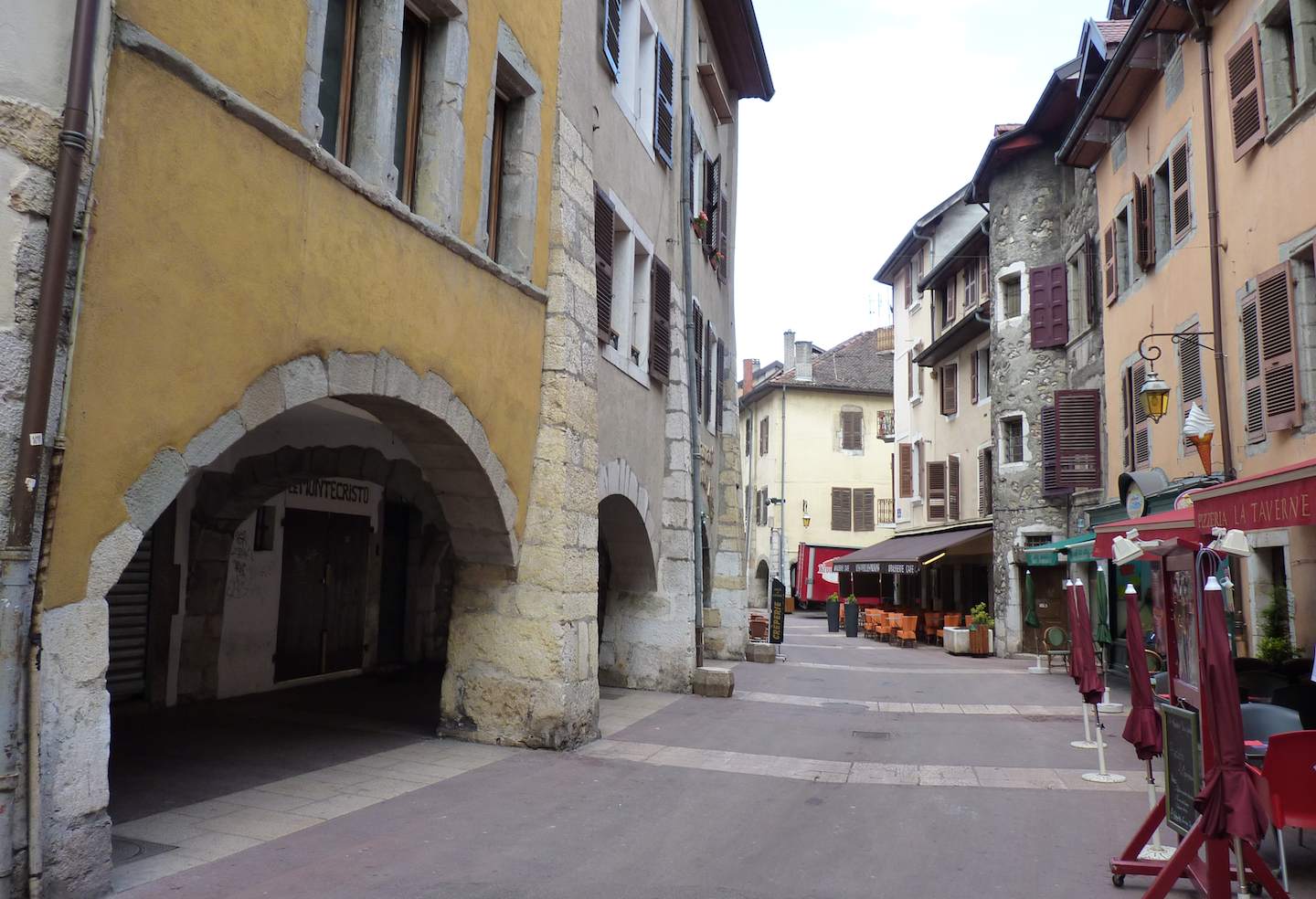
Some of the medieval streets, in concentric circles around the base of the chateau, have massive arcades.

Water flows through medieval Annecy in multiple channels of the Thiou Canal, so this area is called "Little Venice."

The buildings along the canal are picturesque, and perhaps self-consciously so.

The various channels of the canal are so pervasive and complex that one of them actually flows right under the city's cathedral.

As a resort city, Annecy has all the attractions a visitor could want, including artisanal ice-cream shops. If you ever wanted to know what a smurf tastes like, here's your chance. One of these flavors is "Schtroumpf," which is what smurfs are called in France.

Where the canal meets the Lac d'Annecy, boats lie ready to give rides to visitors.

Wednesday, May 12, 2010

Grand Department Stores in Paris

Paris's big department stores have buildings that make clear their grandeur. Last weekend Susie and I gawked at a couple of them.

On the right bank, the Galeries Lafayette knocks you back with opulence. The building, in a neo-Byzantine style with a 100-foot-high atrium topped by a glass dome, was inaugurated in 1912.

It would be difficult to make this building any more ornate. Every surface is decorated, every border sculpted.

On the left bank, Le Bon Marché presents a nearly comleted contrast of styles. Even though it was built 25 years before the Galeries Lafayette, its design is, to contemporary eyes, much more modern. The building, designed by Louis Charles Boileau and Gustave Eiffel, was completed in 1887.

Although the overall effect is clean, Le Bon Marché includes ornamental details that modern designs would likely skip, such as this elaborate overhead cover for a large ventilator.

Tuesday, May 11, 2010

Chapels on Hills

Across France, from the Sacré Coeur in Paris to St-Michel de l'Aguille in Le Puy, churches large and small perch on high ground. In Alsace-Lorraine, Susie and I visited two sites with chapels on hills. As is sometimes the case, the less spectacular building is the more interesting.

The village of Dabo, about 20 miles west of Strasbourg, lies below a dramatic sandstone rock. On this rock stands the Chapelle Saint-Léon, which was built in 1889, roughly contemporaneous with the Sacré Coeur. I think the aftermath of the Franco-Prussian War saw the rise of a nationalistic Catholicism, and these churches, like the Basilica of the Immaculate Conception in Lourdes, consecrated in 1876, reflect that movement.

From the Dabo rock, you can see for miles across the Vosges.

The chapel of Mont St-Pierre, located about 12 miles east of Metz, is much less grandiose. Indeed, the Mont St-Pierre itself, while certainly a high spot in its topography, stretches the definition of "mont."

But its history goes back centuries; in fact, there may have been a Roman temple on this spot. For centuries, there was a large church here that served as the parish church for the handful of villages in the area. The church was linked to the Benedictine monks of the St-Pierre-aux-Nonnains monastery in Metz--a building that itself was built in the Third Century as a Roman basilica. As the surrounding villages built their own churches, the St-Pierre church lost its purpose. The church was razed in 1854, and the commemorative chapel was built in 1865. The Mont St-Pierre also has a monument remembering French, American and Polish forces who fought in World War II.

Even if the Mont St-Pierre is not the most rugged of peaks, it still offers beautiful views of the Lorraine countryside.

Saturday, May 1, 2010

The Vosges du Nord

This wraps up my series of posts on our visit to the Vosges du Nord and the lower country to the west. The posts included:

World War II, Before and After, Below the Vosges

The rolling landscape west of the Vosges du Nord contains hard reminders of the tragedy of World War II, both from before the war and in its aftermath. As you drive the back roads, you encounter the earthen and concrete ruins of the Maginot Line, France's defensive system from the inter-war period. Some of the fortifications, like at Simserhof, are large, complex, well-preserved, and have extensive guided tours. Others are individual bunkers or pillboxes, just lying there alongside the road. Susie and stopped to explore the small set of fortifications at Macheren.

One odd part of this defensive system was the Ligne Maginot Aquatique, a complex of fortifications, dams, reservoirs, dikes and ponds designed to create floods that would bar invasion.

The Ligne Maginot Aquatique was part of the Sarre sector (as in Sarrebourg, Sarreguemines, ...); you can see it at the center of this map, numbered as sector 13, represented as an area of water. It covered the border between the well-defended areas around Metz and Lauter.


Along with the concrete structures, the remnants of the Maginot Line at Macheren include earthworks such as zig-zag ditches running between the bunkers. Macheren is at the west end of the recently designated Route de la Ligne Maginot Aquatique. The bunkers, so plainly for war, now contrast with the gentle countryside of the Moselle. At the start of World War II, though, this land was soaked in blood.

As odd as the strategy of the Ligne Maginot Aquatique seems to us now, it was precisely in the Sarre sector, 18 kilometers long, that French forces won their only battle against the German invasion. On June 14, 1940, these soldiers defeated the German army in an awful battle that ended with 700 French and 1200 Germans dead. June 14 was also the day that Paris fell to the Wehrmacht. The French resistance at the Ligne Maginot Aquatique had been successful but futile. The government of Marechal Petain signed the armistice of surrender on June 22.

The aftermath of the war I find even more sobering. French and German military cemeteries from World War I were already scattered across the countryside. The American dead of World War II from fighting in Alsace and Lorraine are buried in the Lorraine American Cemetery, just north of St-Avold. They were killed while driving German forces from Metz toward the Siegfried Line and the Rhine River. The American soldiers commemorated at the Bitche citadel would be buried here. More Americans servicemen and women lie here than even in Normandy; the final resting place for 10,489 Americans, the Lorraine American Cemetery is the largest American military cemetery of the Second World War.

The cemetery's memorial includes a ceramic mural depicting the fighting. I realized that Susie and I had visited many of the places on this map, some right around Metz, not knowing that they were battlefields.

The cemetery comforts in its serenity and calm but chills in its scope and finality. We were fortunate enough to talk with the cemetery's assistant superintendent, an American who clearly thinks deeply about the fallen with whose care he is entrusted.


The memorial, mostly quite simple, has a tall statue of Saint Avold over the door.


In the interior, you can see the maps of France and Alsace-Lorraine on the wall to the left. Toward the back wall are the tablets of the Ten Commandments and a cross on an altar. And above the altar are figures representing the eternal struggle for freedom. The central figure stands, I think, for the soldiers in the cemetery. And to his sides are religious and military heroes, of history and myth: King David, Emperor Constantine, King Arthur, George Washington.

Another aftermath of the war makes its self apparent, if more subtly, as you drive
through the region's villages: abandoned synagogues. Before the war, many of the villages had substantial Jewish populations. They built synagogues, often in the Moorish style then current, and often next to or across the street from city hall. Jewish life was, I gather, a regular part of village life. After the war, these Jewish communities had been destroyed, like most of their synagogues. Many people were deported and killed during the war, and after the war the survivors moved away or died.

In some cases, Jews in Lorraine villages rebuilt their synagogues. The synagogue in Foulquemont, destroyed by the Nazis, was rebuilt in 1962 in a contemporary style. But the community died out, and the synagogue was closed in 2005. It remains abandoned and unused.

The Bitche Citadel

No matter how funny the town's name looks to Americans, Bitche holds meaning for the French as a wrenching yet noble part of their history. On its long sandstone ridge, the Citadel of Bitche stands above the town, both the emblem and the actual place of a remarkable story of French survival in the face of the Prussian army.

A castle stood on the ridge as early as the 12th Century, but Vauban gave the citadel its present form in the 1620s. And even though much of the fortress was destroyed in 1698 when the area was restored to Lorraine, the fortress was rebuilt from 1741-54 to Vauban's original design. Here's how the fortress looked in 1794, when this scale model was built. (The history of the model is itself an interesting story, even involving Metz, but would be something of a detour for this post.)

Since then, the city of Bitche grew around the base of the citadel. The entrance still impresses. Imagine trying to force your way up that ramp to the gate, while being attacked from the walls above and behind you.


The design of the fortress shows Vauban's ingenuity. There are bastions at the east and west ends of the citadel, separated from the main fort by deep moats. This bridge crosses from the main part of the fortress to the "small head" bastion at the east end of the ridge.


The gate to the bridge is closed, but here's what it would be like if you wanted to cross.

The citadel is complex. Here's a diagram of the fortress's layout.

Indeed, the Bitche citadel, conceived by Vauban and built twice to his design, suffered through multiple attacks and sieges but never broke. The most celebrated and heroic defense came in 1870-71, when the French garrison, swelled by troops staggering to the citadel from horrific battle losses to the Prussians, and by townspeople fearing the Prussians' attack, successfully defended the citadel during a 230-day siege, attacks from the 7000 Prussian soldiers massed against it, and three periods of intense shelling.

While the citadel's ramparts, moats and underground spaces are intact, all the buildings on the top of the fortress, save the chapel, were destroyed in the Franco-Prussian War and World War II. The citadel's underground passage, tunneled into solid rock, now house a remarkable multimedia experience--a sort of feature film that takes you from room to room--that makes the siege and its defenders real.

This "cinematic tour" is brilliant. You start out in something of a traditional movie theater for the first eight minutes, then move to subsequent spaces for succeeding segments, with the screens integrated into the rooms in a number of ingenious ways. You hear the audio on the same wireless headphones that you use for visiting the whole citadel, with commentary in your own language. The movie is graphic, personal, and simply incredibly well done. It's the best introduction to the history, and best use of, a historic monument that I have ever seen. When you walk back up to the surface of the fort you feel like the fighting is still going on around you.

The movie handles transitions between rooms cleverly, too. In the first segment, at the end, the characters in the film are watching the film in the very room you're in, and when they--on screen--get up to move to another room you get the idea quickly. The movie, produced in 2005 and installed in 2006, involved nearly 700 extras, 100 technicians, and 40 principal actors. The movie includes imagined newsreel footage of historical figures such as Napoleon III and Kaiser Wilhelm that concisely explains the political and military events leading to the siege and its aftermath.

The underground part of the citadel stored a huge amount of supplies, especially flour and gunpowder. Water from rainfall ran into cisterns, and a human-powered machine drew water from a deep well. Two soldiers would walk inside the machine, something like a giant hamster wheel, causing the a full bucket to rise while an empty bucket descended.

Faced with the Prussian attack, Commander Louis-Casimir Teyssier, who had been sent to Bitche as a backwater assignment, and his soldiers rose to the occasion. Indeed, Teyssier refused to give up the fight even after France's defeat and the subsequent armistice until he received official orders. The garrison marched out of the citadel, undefeated, after the final peace treaty. Teyssier earned the Legion of Honor, among many other honors. Bitche's high school is named for him. Commander Tessier lived until 1916.

The city of Bitche also expressed its appreciate to a later group of soldiers. This plaque, placed on the walls of the citadel by the city and the U.S. 100th Infantry Division remembers the nearly 3,000 soldiers of the Division who were killed, wounded, missing or captured in the three-month battle for the Bitche region in 1944-45.

Today, the base of the Bitche citadel shelters a Garden of Peace. The citadel's looks over a city and surrounding mountains free of battle and bombardment. The ramparts still stand, and grass grows over the roofs and the slopes.